0 Articles
0 News
0 Properties
0 Page
Add information from throughout the site by clicking the "Add" link.
Click "View Custom Report" to view your customized report. Email, print or create a PDF.
![]() Kimball, Nebraska
Kimball, Nebraska ![]() 308.235.3639
308.235.3639 ![]() econdev@kimballne.org
econdev@kimballne.org
![]()
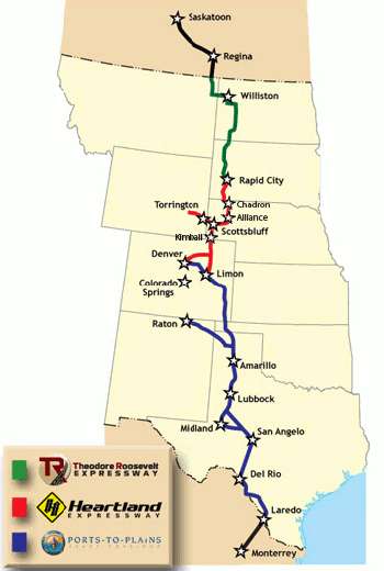 Kimball sits on the intersection of Interstate-80 and US Highway 71, which is a part of the Heartland Expressway. The Heartland Expressway is a 556 mile federally designated trade corridor covering four states: Colorado, Nebraska, Wyoming, and South Dakota. The Heartland traverses some of the most productive agriculture and energy rural regions in the United States. Adding to the quality of life in this area is the internationally renowned tourist industry including the Colorado Rocky Mountains, the Black Hills, Scottsbluff National Monument, and Fort Laramie as well as a rich cultural heritage. As the central portion of the Ports-to-Plains Corridor, the Heartland Expressway completes the necessary transportation infrastructure for movement of goods and products from Mexico to Canada. The Ports-to-Plains Corridor follows the energy corridor that spans the heartland of North America. PtP runs directly though through four of the major shale basins (Eagle Ford, Permian, Niobrara, and Bakkan) and ends at the Oil Sands of Alberta. Kimball sits with easy access to many others from both the Heartland Expressway and I-80.
Kimball' Municipal Airport (IBM) is 3 miles south of town on Hwy 71. More Information
| Dimensions: | 6199 x 75 ft. / 1889 x 23 m | ||
| Surface: | Concrete, in good condition | ||
| Weight bearing capacity: | Single wheel: | 30.0 | |
| Double wheel: | 45.0 | ||
| Runway edge lights: | Medium intensity | ||
| RUNWAY 10
|
RUNWAY 28
|
||
| Longitude: | 103-41.296050W | 103-39.989767W | |
| Elevation: | 4925.5 ft. | 4899.5 ft. | |
| Scottsbluff Regional Airport (BFF) | 48 miles |
| Cheyenne Regional Airport (CYS) | 65 miles |
| Denver Internationa; Airport (DEN) | 150 miles |
Export as CSV
To view Kimball's Location One page, click here.